In the vast expanse of the Bay of Bengal, a mysterious atmospheric ballet occasionally unfolds when two cyclonic systems encounter each other. This fascinating meteorological phenomenon, known as the Fujiwhara effect, creates a spectacular dance between tropical storms that can significantly impact weather patterns across India and neighboring regions.
What is the Fujiwhara Effect?
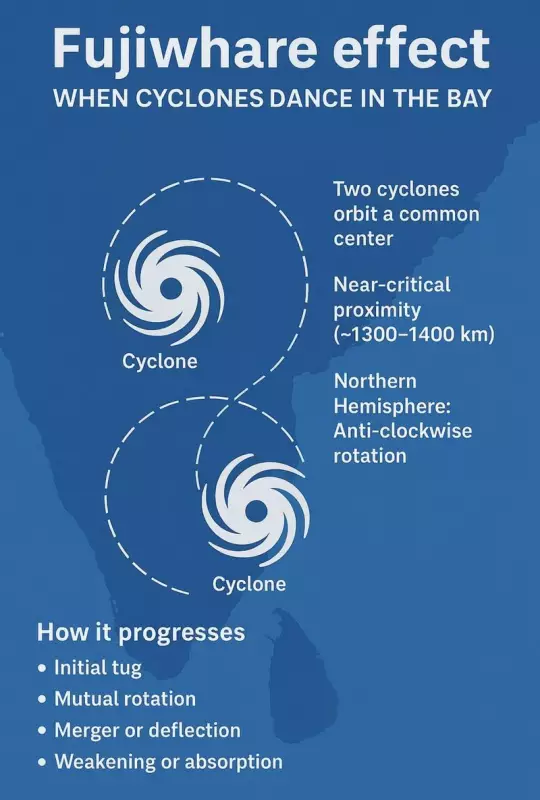
The Fujiwhara effect describes the unique interaction that occurs when two cyclones spin close enough to influence each other's movement. Named after Japanese meteorologist Sakuhei Fujiwhara who first documented this behavior in 1921, this phenomenon transforms ordinary cyclone patterns into an intricate atmospheric waltz. When two cyclonic systems come within approximately 1,400 kilometers of each other, they begin to orbit around a common central point, creating a mesmerizing spiral dance in the sky.
This interaction follows specific physical principles where the cyclones either merge into a single, more powerful system or engage in a graceful circling motion before eventually separating. The intensity and outcome of this interaction depend on multiple factors including the size, strength, and distance between the participating weather systems. Larger cyclones typically dominate smaller ones, often absorbing them completely during this atmospheric tango.
Recent Examples in Indian Waters
The Bay of Bengal has witnessed several notable instances of the Fujiwhara effect in recent years, demonstrating its relevance to Indian meteorology. One of the most significant events occurred in 2017 when Cyclone Maarutha interacted with another weather system, creating complex forecasting challenges for meteorological departments across the region.
Another remarkable case unfolded in 2018 when twin cyclones Luban and Titli engaged in this atmospheric dance. More recently, in 2020, the interaction between Cyclone Gati and another weather system near the Somali coast demonstrated how this phenomenon isn't limited to the Bay of Bengal but can occur across the northern Indian Ocean.
These events highlight the importance of understanding the Fujiwhara effect for accurate weather prediction and disaster preparedness in coastal regions of India. The Indian Meteorological Department (IMD) now closely monitors potential Fujiwhara interactions during cyclone season to improve forecast accuracy and early warning systems.
Implications for Weather Forecasting and Safety
The Fujiwhara effect presents significant challenges for meteorologists and disaster management authorities. When two cyclones interact, their paths become increasingly unpredictable, making it difficult to issue timely warnings to vulnerable coastal communities. This unpredictability can affect evacuation plans, shipping routes, and emergency preparedness measures across affected regions.
For India, with its extensive coastline and numerous coastal cities, understanding this phenomenon is crucial for minimizing potential damage and saving lives. The interaction between cyclones can lead to unexpected intensification or changes in direction that might catch communities off guard. Enhanced satellite monitoring and advanced computer modeling have become essential tools for predicting these complex interactions.
Research indicates that climate change might influence the frequency and intensity of such interactions in the future. Warmer ocean temperatures could potentially create more favorable conditions for cyclone formation and interaction in the Bay of Bengal, making the study of the Fujiwhara effect increasingly important for long-term climate adaptation strategies.
As meteorological science advances, Indian researchers continue to study this fascinating phenomenon to improve forecasting models and enhance disaster preparedness. The dance of cyclones in the Bay of Bengal remains one of nature's most spectacular atmospheric performances, one that demands both respect and scientific understanding from those who live in its potential path.