A recent analysis by the Indian Space Research Organisation (ISRO) has cast serious doubt on official claims of a significant reduction in crop residue burning, or stubble burning, in northern India. The study suggests that while satellite data might show a decline, the reality on the ground is more complex, with farmers adapting their practices to avoid detection.
Satellite Data vs. Ground Reality: The Evasion Tactic
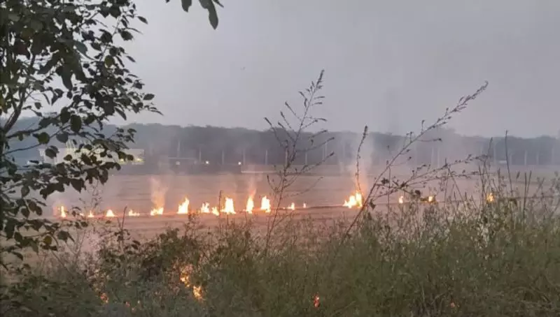
The core finding of the ISRO study, conducted by scientists at the National Remote Sensing Centre (NRSC), is that a substantial number of farmers have shifted the timing of their farm fires. Instead of burning crop residue during the daytime, when satellites like NASA and ISRO's own resources are actively monitoring, they are now conducting these burns primarily during the night and early morning hours.
This strategic shift allows the fires to largely escape the watchful eyes of polar-orbiting satellites, which pass over the region at fixed times. Consequently, the official figures derived from this satellite data present an incomplete and potentially misleading picture, showing a decrease that may not accurately reflect the actual volume of stubble being burned.

Analyzing the Evidence: Aerosols and Thermal Anomalies
The ISRO scientists employed a multi-faceted approach to uncover this discrepancy. They cross-referenced data on aerosol optical depth (AOD)—a measure of fine particles in the air—with records of thermal anomalies (fire spots) from satellites. Their analysis revealed a critical mismatch.
Despite a reported 21% drop in fire counts in Punjab and a 41% drop in Haryana during the peak stubble burning period of October-November 2023 compared to 2022, the levels of airborne aerosols remained persistently high. This indicates that pollution from biomass burning was still very much present in the atmosphere, even though satellites were recording fewer fires.
The study pointedly notes that the reduction in fire counts is "not commensurate" with the observed aerosol loading, strongly implying that a large number of burning events went undetected by the standard satellite monitoring protocols.
Implications for Pollution and Policy
This revelation has significant implications for air quality management and government policy in North India, particularly for the National Capital Region (NCR). Stubble burning is a major contributor to the severe air pollution episodes that engulf the region every winter.
If the actual burning is much higher than reported, it undermines the effectiveness of current mitigation strategies and claims of success. It suggests that farmers, possibly due to a lack of affordable and accessible alternatives for managing paddy straw, are finding ways to continue the practice while avoiding the scrutiny of authorities who rely on satellite data for enforcement and assessment.
The ISRO study calls for a more robust monitoring mechanism that can account for this nocturnal shift. It highlights the need to integrate data from geostationary satellites, which can provide continuous observation, and ground-based validation to get a true sense of the scale of stubble burning. Until then, official statistics on the reduction of farm fires should be interpreted with caution, as the problem may simply be moving into the shadows of the night.