Satellite Imagery Exposes Extensive Damage Across Middle East Amid Iran Conflict
Newly released satellite images are now offering one of the most comprehensive visual assessments of the widespread destruction caused by the ongoing Iran war, revealing significant damage to military installations, strategic ports, air bases, and other critical facilities throughout the Middle East region.
Unprecedented Visual Evidence Emerges
Since the conflict began on February 28, 2026, much of the actual impact has remained difficult to evaluate, particularly within closed military compounds and restricted security areas. However, imagery released in recent days is providing unprecedented visual documentation of strikes both inside Iran and at American and allied positions across the Gulf region.
The United States and Israel have been conducting coordinated strikes against a broad spectrum of targets within Iran, including leadership figures, military bases, missile and air defense sites, and positions associated with the paramilitary Revolutionary Guard and Basij forces. Iran has responded with sustained drone and missile attacks targeting Israel and nearby Gulf Arab nations, creating a complex multi-front conflict.

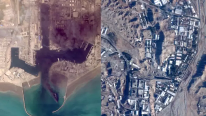
Dramatic Destruction at Iranian Port Facilities
Some of the most striking images originate from Bandar Abbas, home to a major Iranian military port strategically located near the vital Strait of Hormuz. Satellite photographs captured on March 2 clearly show multiple ships ablaze at the port facility. The United States military's Central Command has confirmed that it has sunk or damaged more than 100 Iranian vessels during the course of the war.
Critical Strikes on Iranian Military Infrastructure
Planet Labs satellite images from March 6 reveal substantial damage to several buildings at Iran's Parchin military base located outside Tehran. The International Atomic Energy Agency has long suspected this site was previously used for tests involving high explosives that could potentially trigger a nuclear weapon. While Iran maintains its nuclear program is entirely peaceful, the IAEA, Western intelligence agencies, and other observers assert that Tehran maintained an active weapons program until 2003.
Israel's military has stated that its strikes on Parchin specifically targeted "infrastructure used for the production of essential components for the development of various weapons." The site has also been historically linked to Iran's ballistic missile development program, adding another layer of strategic significance to the damage documented.
Significant Damage to Allied Military Bases
In Bahrain, satellite imagery shows major structural damage at the headquarters of the United States Navy's 5th Fleet. A March 1 image reveals a primary building completely destroyed, with two radomes—the geodesic domes that protect radar antennas—apparently struck by Iranian missile and drone fire. A subsequent image from March 6 shows additional building damage at the same facility.
The United States Navy has not provided a detailed assessment of the damage sustained at the base, though Iran has repeatedly claimed responsibility for attacking the installation. Online videos circulating on social media platforms have also shown incoming fire targeting the strategic location.
Regional Air Bases Suffer Substantial Impact
A March 1 Planet Labs image additionally shows damage to one of the buildings at Qatar's Al Udeid Air Base, which serves as the forward headquarters for the United States military's Central Command. Neither Qatar nor the United States has officially acknowledged this damage publicly.
In Saudi Arabia, an Iranian attack successfully struck Prince Sultan Air Base, with a March 15 satellite image confirming visible damage at the strategic location. Further damage has been documented in the United Arab Emirates, where satellite images taken March 15 by an Airbus Defense and Space Pléiades Neo satellite and analyzed by the Associated Press show significant impact at Abu Dhabi's Al Dhafra Air Base.

The imagery reveals one set of hangars in the northwest section of the facility appearing damaged, while another hangar in the southeast appears completely burned out, with a nearby hangar showing clear roof damage. What specific equipment or aircraft were housed within these hangars remains unclear at this time.
Strategic Importance of Damaged Facilities
Al Dhafra Air Base typically hosts approximately 2,000 American troops and has served in recent years as a major operational center for missions involving armed drones and advanced F-35 stealth fighter aircraft. The United States military had previously referred to this installation only as a base in "southwest Asia" before the United Arab Emirates became more transparent about the American military presence within its territory.
Additional International Facilities Targeted
Elsewhere in Abu Dhabi, satellite images from March 3 show damage to two large hangar-style buildings at France's Camp de la Paix naval base. This facility is situated near Zayed Port and adjacent to the Cultural District, which houses the Louvre Abu Dhabi and other major cultural institutions.
Satellite Imagery Documents Conflict-Related Fires
Satellite technology has also proven instrumental in identifying major fires directly linked to the ongoing conflict. Landsat images captured on Monday clearly showed a substantial fire at Dubai International Airport after an Iranian drone strike ignited a fuel tanker, sending a massive plume of black smoke into the atmosphere.
Another significant fire was visible on Monday at Oman's southern port in Salalah, which came under attack from suspected Iranian drones on March 11. While Tehran has officially denied launching these drone attacks, the fire appears to have been burning continuously since the initial assault occurred.
The comprehensive satellite imagery now available provides undeniable visual evidence of the extensive physical destruction occurring across multiple Middle Eastern nations as the Iran war continues to escalate, affecting military, economic, and strategic infrastructure throughout the region.