Kolkata's Thunderstorm Relief Ends, Hot & Humid Days Ahead from Friday
While thunderstorms between Wednesday night and Thursday morning brought significant rainfall and pulled temperatures well below normal levels, Kolkata residents should brace for a return to hotter days starting from Friday. The city is poised to enter a hot and humid phase as the mercury begins climbing once again.
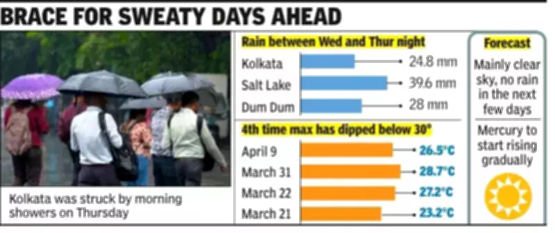
Significant Rainfall Recorded
The Met office reported that Alipore recorded 24.8 mm of rain between Wednesday evening and Thursday morning, with 9.4 mm occurring specifically toward Thursday morning. This marked the highest 24-hour rainfall count of the season, capping five consecutive days of thunderstorm activity in the city.
"The rain was significant enough to pull the mercury further down," said Met scientist HR Biswas, head of the Regional Meteorological Centre in Kolkata. "Thundershowers were more intense in Dum Dum and Salt Lake, with even higher rain amounts."

Most rainfall occurred between late evenings and late nights, though Thursday saw substantial precipitation early in the morning as well.
Weather Systems Behind the Storms
The current thunderstorms were triggered by several meteorological factors:
- An upper air cyclonic circulation over Bangladesh and neighboring areas
- An east-west trough extending from this cyclonic circulation
- Another upper air cyclonic circulation over Odisha
On Wednesday, these systems were further fueled by the impact of a western disturbance, leading to intensified rainfall across the region.
Wind Conditions During the Storm
While Kolkata experienced gusty winds during Thursday's thunderstorm, Met officials confirmed the wind speed and criteria didn't qualify as a squall. However, a squall did pass over Dum Dum with wind gusts reaching up to 57 kmph.
Gusty winds were also recorded at one or two places across several districts including West Burdwan, South 24 Parganas, Nadia, Purulia, and Howrah during the storm period.
Temperatures Plunge Below Normal
The maximum temperature, which had been below normal for four consecutive days, plummeted further on Thursday to 26.5°C - a remarkable 8.7 notches below the normal mark and below 30°C for the first time in this period.
The sharp drop in daytime temperatures narrowed the gap between day and night readings to just about 5 degrees. The minimum temperature stood at 21.3°C, which was 3.9 notches below normal.
Hotter Days Ahead
Met officials indicate that the weather systems responsible for the recent thunderstorms are gradually weakening, reducing rain possibilities from Friday onward.
"From Friday onwards we can expect mainly sunny skies and the inflow of dry wind systems - either westerly or north-westerly winds," explained Biswas. "The maximum temperature is likely to reach 32°C and then gradually climb to around 35°C in subsequent days."
While 32°C remains below the normal temperature mark for this period, Met officials note that the sharp surge from Thursday's 26.5°C will create noticeable discomfort and cause people to sweat as humidity levels increase alongside the rising temperatures.
The Met office currently sees no rain in Kolkata's forecast for the next several days, marking a definitive shift from the recent thunderstorm pattern to a sustained period of hot, humid weather conditions.