New Yorkers returning to work or traveling after the Christmas holiday are set to face significant disruptions as a powerful winter storm prepares to sweep across the city and surrounding regions. Forecasters warn of heavy snowfall and hazardous conditions that will create dangerous travel scenarios during the busy post-festive period.
Storm Timing and Expected Snow Accumulation
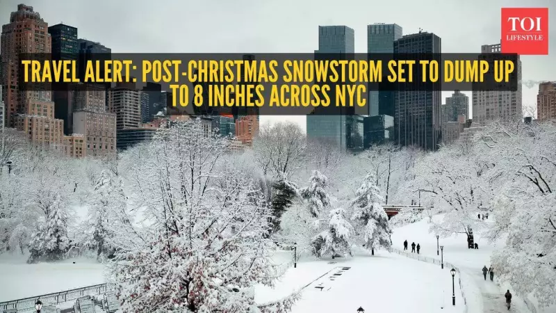
The impact of the fast-moving storm will begin to be felt across New York City and the broader tri-state area from Friday afternoon. The snowfall is predicted to continue into the early hours of Saturday, missing a white Christmas but squarely hitting peak travel hours. According to AccuWeather senior meteorologist Tyler Roys, parts of the city could witness between three and six inches of snow.
Surrounding areas are bracing for even higher totals. The Interstate 287 corridor connecting New Jersey and New York may receive as much as eight inches of snow. Roys indicated that sections of Long Island could also see accumulations approaching the eight-inch mark. Within the five boroughs, Manhattan, Queens, and Brooklyn are likely to be on the lower end of the forecast range.

Travel Impacts and Hazardous Conditions
The snowfall is expected to start causing problems around 3 p.m. on Friday and gradually taper off by approximately 10 a.m. on Saturday. This timing directly threatens the Friday evening commute and Saturday morning travel plans. "Travel is going to be impacted basically starting with whatever the Friday evening commute … into the Saturday morning hours," Roys told The Post.
Forecasters are also monitoring the potential for sleet to mix into the storm, particularly to the south and west of New York City. This factor could further worsen road conditions, making them extremely slick and treacherous. Roys confirmed that the likelihood of three to six inches for the area is quite definite.
Snow Characteristics and Christmas Day Forecast
Interestingly, the expected snowfall is likely to be of a lighter and fluffier variety. While this may reduce the risk of extreme weight-related issues, Roys noted it would be less ideal for activities like building snowmen or having snowball fights.
In contrast, Christmas Day itself is predicted to remain dry but cold. Morning temperatures will hover around freezing, with breezy conditions developing by early afternoon. The day will see a mix of sun and clouds. However, by nightfall, temperatures could plunge into the upper teens in the colder pockets of the region, setting the stage for the incoming storm.
Residents and travelers are strongly advised to monitor updates, consider altering travel plans, and exercise extreme caution on the roads as this significant winter weather event unfolds.