Cyclonic Circulation Over Bengal to Trigger Thunderstorms and Rain for Four Days
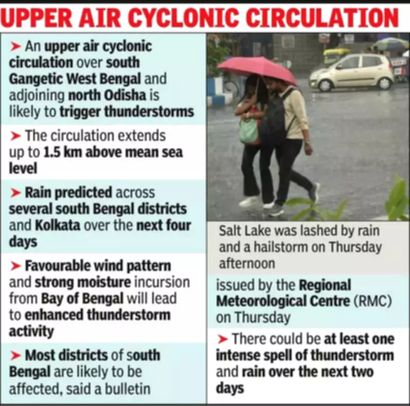
An upper air cyclonic circulation has formed over south Gangetic West Bengal and adjoining north Odisha, extending up to 1.5 km above mean sea level. This weather system is expected to bring thunderstorms and rain across several south Bengal districts, including Kolkata, over the next four days, according to the Regional Meteorological Centre (RMC).
Enhanced Thunderstorm Activity Forecast
In a bulletin issued on Thursday, the RMC stated that favorable wind patterns and strong moisture incursion from the Bay of Bengal are likely to enhance thunderstorm activity in West Bengal. An orange alert has been issued for the entire south Bengal region on Friday, with thunderstorms anticipated at one or two places in all districts.
Weather scientist Sourish Bandopadhyay explained, "Chances of thunderstorm and rain are high on Friday and Saturday. Thereafter, the city and south Bengal may receive sporadic thunderstorms. There is again a possibility of multiple thunderstorms striking Kolkata and south Bengal districts on March 31."

Recent Weather Events and Impacts
On Thursday, North 24 Parganas experienced a severe thunderstorm with wind speeds of 40-50 km/hour, which forced Chief Minister Mamata Banerjee's aircraft to hover in the sky due to unsafe landing conditions at Dum Dum airport. Salt Lake received a hailstorm, while most parts of north Kolkata were lashed by thunderstorms and rain between 3:30 pm and 4:30 pm.
Bandopadhyay noted that this was a localized system centered around Dum Dum, affecting only the northern and eastern fringes of Kolkata. "It didn't go beyond the area. So, central and south Kolkata received no rain on Thursday," he said.
Temperature and Future Predictions
Kolkata recorded a maximum temperature of 33.2°C and a minimum of 25.8°C on Thursday. Over the next few days, weather conditions are expected to remain ideal for thunderstorms. "Now, we have a circulation. Over the next two days, a trough may form. There is also some impact of a western disturbance. These will keep the city cloudy and generate thunderstorms. The chances of a severe thunderstorm are high on at least one out of the next two days," added Bandopadhyay.
Other Affected Regions
In addition to south Bengal, districts like Darjeeling, Kalimpong, and Jalpaiguri were also hit by thunderstorms and rain. The rain was moderate in most hill districts, but storms were accompanied by wind speeds of 30-40 km/hour.
Last Saturday, most parts of Kolkata received a continuous downpour from 2 am to 11 am, with some areas in south Kolkata experiencing a hailstorm between 2 am and 3 am. This was triggered by a low-pressure trough over south Bengal and a western disturbance stretching from Haryana to Chhattisgarh.