Bengaluru: How badly Bengaluru's once cool climate has been mangled in recent decades is now evident in what scientists describe as the rise of "heat archipelagos" across the city — clusters of extreme heat pockets scattered through the landscape and increasingly merging with each other.
Borrowed from geography, where it refers to chains of islands, the term now paints a stark picture of how heat is fragmenting and spreading across the city.
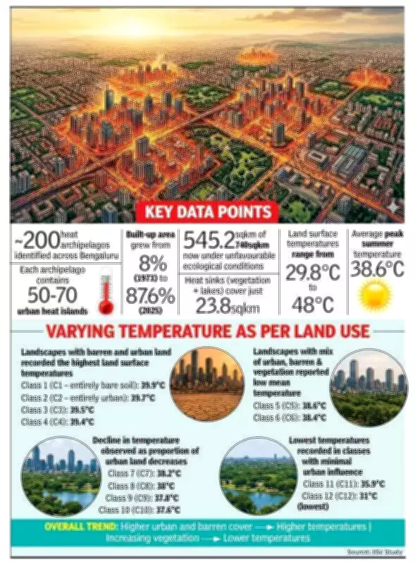
A team from the Indian Institute of Science (IISc), examining the micro-level relationship between land surface temperature (LST) and land use (LU), has traced this phenomenon to the rapid spread of paved and built-up areas, concomitant with the sharp decline in green cover, open spaces, and waterbodies. The city is now estimated to have about 200 heat archipelagos, each consisting of 50-70 urban heat islands (UHIs), landscapes significantly warmer than adjoining areas because of glass facades, paved surfaces, and concrete structures.

The study traces a dramatic transformation in Bengaluru's land profile, with built-up area surging from just 8% in 1973 to 87.6% in 2025. Of the city's 740 square kilometer area, 545.2 square kilometers is now categorised as having unfavourable ecological conditions. Land surface temperatures range between 29.8 degrees Celsius (favourable conditions) and 48 degrees Celsius (unfavourable), with the average temperature 38.6 degrees Celsius in peak summer.
Dense Built Environments
The study attributes this to dense built environments with poor airflow and diminishing tree cover, compounded by the degradation of lakes that once provided natural cooling through evaporation. "Even modest increases in vegetation cover can significantly reduce heat levels, as is the case with the IISc campus or Cubbon Park, Lalbagh, and parts of south and west Bengaluru," explained Prof TV Ramachandra, who co-authored the study with Rajesh Singh Rana, S Vinay, and Bharath H Aithal.
"The city has effectively transitioned from a porous, cooling landscape to a heat-retaining concrete expanse," Prof Ramachandra said, cautioning that unregulated growth has made Bengaluru "greenhouse gas-rich, water-scarce, non-resilient and unliveable," depriving residents of clean air, water, and a healthy environment.
"On the contrary, the vegetation and lakes referred to as heat sinks are only 23.8 square kilometers of the city's area. The hot spots are not continuous but occur as fragmented patches, forming what is described as an urban heat archipelago," Prof Ramachandra said, adding that the study identifies heat islands across Bengaluru, particularly concentrated in the northern and eastern regions, where their combined impact creates larger heat archipelagos.
Based on these findings, the researchers have also engaged with planning authorities to recommend corrective measures. "We have suggested maintaining 30 percent open space with green cover at plot level. The government assured that the outcome of the current research would be incorporated with recommendations in the proposed Master Plan 2031," Prof Ramachandra said.
The study highlights the urgent need for sustainable urban planning to mitigate heat island effects and restore ecological balance in Bengaluru.