A new high-resolution weather radar installed in Mahabaleshwar is expected to significantly improve short-term rain and storm alerts across Pune, Satara, parts of Konkan and Mumbai, offering earlier warnings for intense downpours, thunderstorms and sudden weather shifts in the Western Ghats.
The Indian Institute of Tropical Meteorology (IITM) commissioned the radar under the Mission Mausam initiative. It is called X-band dual-polarisation Doppler Weather Radar. Perched about 1,400 metres above sea level in IITM's High Altitude Cloud Physics Laboratory (HACPL) in Mahabaleshwar, the system is designed to function as a constant 'weather eye', scanning clouds, rainfall and storm systems in real time. Scientists say this vantage point in the Western Ghats, a region known for sharp terrain-driven weather changes, will help decode how heavy rainfall builds up and intensifies.
Impact on Nowcasting
For residents in Pune and surrounding districts, the most immediate impact will be in nowcasting, which refers to hyperlocal forecasts up to three hours ahead. This is particularly crucial in monsoon and pre-monsoon months, when sudden thunderstorms and cloudbursts often catch commuters and local authorities off guard. Kaustav Chakravarty, a scientist at IITM, said the newly installed radar would significantly strengthen short-term weather prediction over Mahabaleshwar and surrounding regions.

'This radar is a very important tool for nowcasting of local weather over Mahabaleshwar, which receives heavy rainfall of around 6,000mm annually. Because it is a polarimetric radar, all microphysical parameters, such as ice, graupel, hail and snow, will be clearly visible over this region and adjoining areas like Pune and Konkan. This is extremely useful for stakeholders working closely with the public,' he said.
He said unlike model-based forecasts, radar-based nowcasting could provide far more precise, location-specific alerts within a short time window. 'A radar can tell you, up to three hours in advance, exactly when and where rainfall will occur by tracking storm movement in real time,' Chakravarty said.
Data Sharing and Applications
'We are providing real-time data to agencies like IMD and NCMRWF for assimilation into their models, which will make forecasts more robust. We are also planning user-friendly dissemination in tourist-heavy locations in Mahabaleshwar and sharing inputs with district authorities so that they can alert the public effectively,' he added.
He said improved weather monitoring over Pune had a strategic value. 'Pune being an Air Force station, the radar will also be useful for the defence sector, with respect to nowcasting of severe weather events,' Chakravarty added.
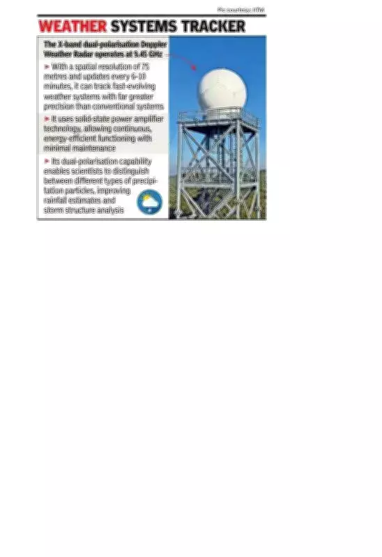
Technical Specifications
The radar operates at 9.45 GHz and uses solid-state power amplifier technology, allowing continuous, energy-efficient functioning with minimal maintenance. Its dual-polarisation capability enables scientists to distinguish between different types of precipitation particles, improving rainfall estimates and storm structure analysis. With a spatial resolution of 75 metres and updates every 6 to 10 minutes, it can track fast-evolving weather systems with far greater precision than conventional systems.
Broader Benefits
Beyond forecasting, the system is expected to feed into early warning systems for floods and severe rainfall, a recurring concern in ghat sections, and support aviation safety, agriculture advisories and water resource planning. Scientists highlighted that the radar's location makes it particularly valuable for studying 'orographic rainfall', where moist winds hitting the Western Ghats trigger intense precipitation. Understanding these processes better could help improve prediction of extreme rain events, which have become more erratic in recent years.