US Trade Deal Map Sparks Geopolitical Waves by Affirming India's Borders
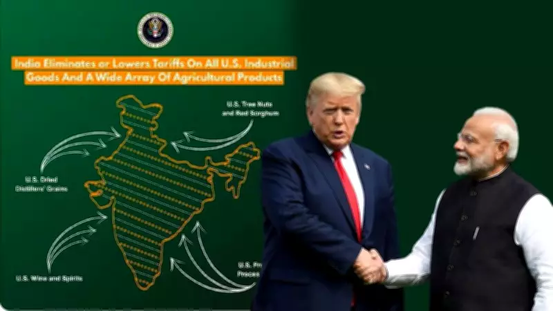
In a move that has sent ripples across international diplomacy, the United States Trade Representative's Office released a map as part of a new interim trade framework with India, which unambiguously depicts the entire Jammu and Kashmir region, including Pakistan-occupied Kashmir (PoK), and Aksai Chin as integral parts of India. This depiction marks a significant departure from previous US maps that typically labeled these areas as disputed territories, and it has left both Pakistan and China visibly red-faced.
A Bold Shift in US Cartographic Policy
The map, unveiled on Saturday alongside the announcement of a trade agreement framework, shows PoK and Aksai Chin within India's borders, aligning with New Delhi's longstanding claims. Historically, US maps have often treated these regions as contested, but this latest visual representation signals a subtle yet profound shift in Washington's approach. Experts interpret this as a clear endorsement of India's territorial sovereignty, potentially recalibrating geopolitical dynamics in South Asia.
Timing Amid Trade Reset and Diplomatic Maneuvers
The release comes at a critical juncture as India and the US seek to mend relations after a period of strain. Previously, the Trump administration had imposed a steep 50% tariff on Indian goods, the highest among US allies. Under the new interim trade framework, this tariff has been slashed to 18%, the lowest for any Asian country, fostering economic cooperation. Concurrently, President Donald Trump has been attempting to re-hyphenate India and Pakistan, reversing the traditional US policy of treating them separately, adding layers to the diplomatic context.

Reactions and Implications for Regional Powers
The map has been warmly welcomed by Indian experts and commentators. Retired Major Gaurav Arya praised it as a strong signal of support for India's position, as reported by India Today. Analysts view this as a setback for Pakistan's recent diplomatic efforts in Washington, where Army chief General Asim Munir has made multiple visits and held high-profile meetings with President Trump. For China, which consistently claims Aksai Chin despite India's objections, this depiction represents a direct challenge, potentially complicating bilateral relations.
New Delhi has frequently raised concerns over inaccurate border depictions by foreign entities, particularly regarding Jammu and Kashmir and Arunachal Pradesh. This US move not only addresses those concerns but also reinforces India's stance on the global stage. As trade and geopolitics intertwine, this map release underscores the evolving nature of US-India relations and their impact on regional adversaries.