Ancient Peruvian Mystery Solved: Monte Sierpe's 'Band of Holes' Was Marketplace and Accounting Tool
Ancient wonders have always captivated human imagination, serving as tangible connections to forgotten civilizations and their ingenious solutions to daily challenges. In the rugged Andes of Peru, one such enigma has baffled researchers for nearly a century—until now. Recent archaeological studies have transformed our understanding of Monte Sierpe's mysterious stone formations, revealing practical purposes behind what once seemed purely ritualistic.
The Century-Old Mystery of the 'Band of Holes'
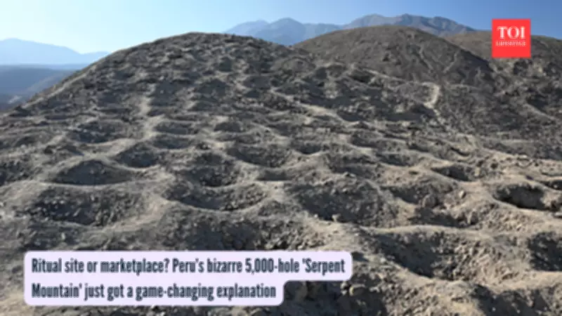
For almost 100 years, the so-called "Band of Holes" at Monte Sierpe (Serpent Mountain) in Peru's Pisco Valley has perplexed experts. This remarkable site features approximately 5,200 shallow pits stretching along a mile-long ridge, with each pit measuring 3 to 6.5 feet wide and 1.5 to 3 feet deep. The holes are arranged in deliberate blocks separated by walkable gaps, suggesting intentional design rather than random formation.
According to a groundbreaking study published in the journal Antiquity, high-resolution drone mapping has revealed sophisticated numerical patterns within the arrangement. Dr. Jacob Bongers, lead researcher from the University of Sydney, emphasized the significance of these findings: "Why would ancient peoples dig more than 5,000 holes into the foothills of southern Peru? We don't yet have all the answers, but we now have promising new data that support innovative theories about how the site was used."

From Storage Pits to Trading Hub
Soil analysis has provided crucial evidence about the site's function. Samples from the pits contained pollen from maize, bulrush reeds (used for basketry), squash, amaranth, cotton, and chili peppers—crops that couldn't have grown naturally on the arid hillside. Science News reports that these low-pollen plants likely arrived through human transportation in baskets rather than wind dispersal.
This discovery strongly suggests the holes served as storage containers for trade goods, strategically positioned to be visible from a distance for bartering purposes. Radiocarbon dating places the site's active use during the 14th-century Late Intermediate Period under the Chincha Kingdom, which dominated regional trade before the Inca Empire's arrival.
A Pre-Inca Marketplace at Ecological Crossroads
Monte Sierpe's location at ecological crossroads near pre-Hispanic roads made it an ideal exchange point. Dr. Bongers proposed: "Perhaps it was a pre-Inca marketplace," noting that the area supported approximately 100,000 people—including traders, farmers, and fishers—who would have exchanged staples like maize and cotton. The site's strategic positioning allowed different ecological zones to converge, facilitating trade between coastal, valley, and highland communities.
The 'Landscape Khipu' Accounting System
Perhaps most remarkably, the study identifies Monte Sierpe as a "landscape khipu"—a physical representation of the knotted-string recording devices used by the Inca for census data and tribute tracking. The pitted layout mirrors khipu patterns, suggesting the site served as an accounting system for mit'a labor taxes after the Inca conquest around 1470.
Dr. Bongers described this as "an extraordinary discovery that expands our understanding of the origins and diversity of Indigenous accounting practices within and beyond the Andes." The Antiquity paper suggests that different kin groups likely dug and maintained specific pit clusters according to social units, creating a physical record of labor obligations and trade transactions.
From Speculation to Evidence-Based Understanding
First photographed by National Geographic in 1933, Monte Sierpe has inspired numerous theories over the decades—from defensive structures to water collection systems. The new research grounds these speculations in concrete evidence of barter economies and administrative record-keeping.

While many questions remain unanswered—including why the site appears unique and the precise nature of its khipu connections—this research represents a significant leap forward in understanding Andean civilizations. As Dr. Bongers acknowledged: "There are still many questions," but the combination of soil analysis, drone mapping, and contextual research has provided the most comprehensive explanation yet for this ancient Peruvian mystery.
The Monte Sierpe discovery underscores how ancient cultures ingeniously adapted their environments for practical purposes, transforming landscapes into tools for commerce, administration, and social organization—a testament to human innovation that continues to resonate centuries later.