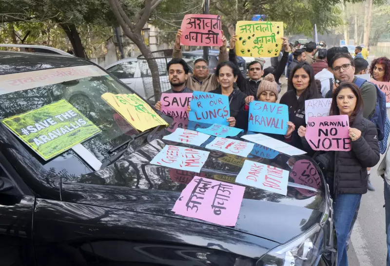
In a significant move to protect the ecologically fragile Aravalli range, the Union government has declared a halt on granting any new mining leases across the hills and ranges until a comprehensive sustainable management plan is finalized. This announcement comes a day after the government clarified that a mere 0.19% of the total 1.44 lakh square kilometre area of the Aravallis could potentially be eligible for mining activities.
Strict Safeguards and a Moratorium on New Leases
Union Environment Minister Bhupender Yadav, addressing the media on Monday, stated that no new mining lease can be granted in the Aravalli landscape until the Management Plan for Sustainable Mining (MPSM) for the entire region is finalized. He further mandated that all existing mining operations must strictly comply with the stringent safeguards recommended by a central committee.
Dismissing protests from certain quarters as a "misinformed campaign," Yadav accused the opposition Congress party of spreading "lies" and "confusion" on the issue. He emphasized that the recent definition of the Aravalli hills adopted by the Supreme Court does not relax any existing restrictions on mining but instead provides additional, scientifically validated safeguards.

The Supreme Court's Scientific Definition
The apex court, in its November 20 order, accepted recommendations for a uniform, policy-level definition of the Aravalli hills and ranges specifically for regulating mining. The court agreed that all landforms enclosed within the lowest binding contour encircling hills of 100 metres or more in height—irrespective of their individual height and slopes—are to be excluded from mining lease grants.
Explaining the rationale for the 100-metre threshold, Yadav noted that the central committee, headed by the Union Environment Secretary, relied on globally accepted scientific standards, specifically the Richard Murphy’s Landform Classification of 1968. This classification identifies landforms rising 100 metres above the local relief as hills and prohibits mining on both the hill and its supporting slopes.
Land Use and the Path Forward
The Aravalli landscape is spread across 37 districts in several states. The dominant land-use category is agriculture, accounting for approximately 55% of the combined geographical area. A significant portion has also been developed into habitations over time, with parts of major cities like Udaipur, Ajmer, Alwar, South Delhi, Gurugram, and Banaskantha falling within the Aravalli boundaries.
Currently, only 277 square kilometres of the nearly 1.44 lakh sq km area is under mining lease. This includes 247 sq km in Rajasthan's 20 districts, 27 sq km in Gujarat's five districts, and 3 sq km in Haryana's seven districts. No mining is permitted in Delhi, whose five districts are part of the range.
Following the Supreme Court's direction, the Environment Ministry has been tasked with preparing the MPSM through the Indian Council of Forestry Research and Education (ICFRE), modelled on a similar plan developed for Jharkhand's Saranda forests. Yadav asserted that claims of 90% of the Aravallis being opened for mining are baseless, as this scientific management plan is yet to be prepared.
"The definition adopted by the Court does not relax any existing restrictions. Instead, it provides additional safeguards through standardised and technically validated basis for regulation, supported by enhanced oversight and scientific planning," the minister concluded, framing the move as a step toward stronger environmental protection for the critical mountain range.