In a move that has ignited fresh controversy, the Union Ministry of Environment, Forest and Climate Change (MoEF) has directed the Survey of India to begin mapping the Aravali ranges based on a new, restrictive definition that recognises only landforms rising 100 metres or more as hills. This development comes even as the ministry announced plans to further reduce permissible mining areas in the ecologically sensitive region.
A New Height-Based Definition for the Aravalis
On December 17, the MoEF issued an office memorandum formalising instructions to the Survey of India. The directive mandates the national survey agency to assist state governments in marking and delineating the Aravali hills on toposheets according to a definition recently adopted by the Supreme Court. This definition, proposed by a technical panel of the ministry and accepted by the apex court on November 20 for mining purposes, states that only a landform rising 100 metres or more from its lowest enclosing contour can be classified as an Aravali hill. Furthermore, hills within a 500-metre radius are to be clubbed as a single range.
The ministry's action follows a meeting chaired by the Environment Secretary on December 8, focused on implementing the Supreme Court's order. The minutes of this meeting confirm that the Survey of India "shall, upon request of the state govts, provide all necessary assistance for marking and delineation of areas... as per the definition... accepted by Hon'ble SC".

Conservation Fears and Expert Warnings
Environmentalists and experts have raised immediate alarms, arguing that this height-based marker linked to local relief will drastically shrink the legally recognised expanse of the Aravalis. The range, which acts as a crucial natural barrier against desertification by separating the Thar Desert from the fertile northern plains, is predominantly low-lying.
M D Sinha, a noted Aravali expert and retired conservator of forests for south Haryana, highlighted the severe implications. He told TOI that hills meeting this new 100-metre local-relief test may account for "less than 10% of the Aravalis." This significant reduction in recognised area could potentially undermine long-standing conservation efforts and open up vast tracts of low-lying hills for non-forestry activities.
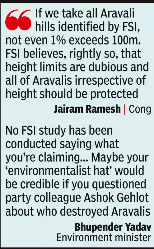
Ironically, the very MoEF affidavit that formed the basis for the Supreme Court's adoption of the 100m definition contained caveats. It noted that height and slope are insufficient parameters for delineating the heterogeneous Aravali ranges and that a sole criterion would lead to "inclusion and exclusion error." The affidavit acknowledged the challenge of applying a uniform definition to a hill system with considerable internal variation.
Parallel Push for Sustainable Mining and Future Controls
Simultaneously, the ministry is advancing another Supreme Court directive: the preparation of a Management Plan for Sustainable Mining (MPSM) for the entire Aravali system. This task has been entrusted to the Indian Council of Forestry Research and Education (ICFRE). The December 8 meeting formalised ICFRE's role, mandating it to prepare detailed action plans, timelines, and ensure all methodologies and data are digitally documented.
A critical condition has been set: until the MPSM is finalised, no new mining leases can be granted in the region. Existing mining operations may continue only in compliance with recommendations from a court-appointed committee. Furthermore, the meeting minutes stress that any district-wise mining plans must treat a range as a single, continuous ecological system to maintain the "continuity and integrity of the Aravali system."
The MoEF has defended its actions, stating that the Supreme Court's adoption of the 100m definition does not dilute existing mining controls. It points out that mining is currently permissible in only 0.2% of the total Aravali area. However, the juxtaposition of defining the hills more narrowly while planning to further curb mining presents a complex picture of the government's approach to managing this fragile ecosystem, leaving its future hanging in the balance.