A severe and persistent winter spell is tightening its grip over vast swathes of India, according to the latest bulletin from the India Meteorological Department (IMD). Issued on the morning of December 24, 2025, the forecast warns of intensifying cold, dense fog, and the likelihood of snowfall and rainfall across different regions in the coming days.
Widespread Fog and Plummeting Temperatures Disrupt Life
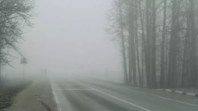
Dense to very dense fog remains the primary weather hazard across the Indo-Gangetic plains. States including Uttar Pradesh, Haryana, Punjab, Chandigarh, and Delhi are experiencing severely reduced visibility during night and early morning hours. IMD observations at 0530 IST on December 24 recorded visibility as low as 50 metres in key locations such as Bareilly, Gaya, Agartala, Jharsuguda, New Delhi, and Chandigarh.
The IMD has indicated that these challenging fog conditions are likely to persist over these regions until at least December 29, marking one of the season's most extended fog spells. The fog has already begun to significantly disrupt road, rail, and air traffic networks. Furthermore, isolated areas in Bihar, Uttarakhand, Madhya Pradesh, Odisha, Jharkhand, Sub-Himalayan West Bengal, and the northeastern states may also encounter dense fog on various days during this period.

Adding to the chill, minimum temperatures are predicted to fall by an additional 2–3 degrees Celsius in several parts of the country over the next 48 hours. Northwest India, Maharashtra, and central India will see a gradual dip, while East India and Gujarat are also forecast for a similar temperature decline. Cold day conditions are very likely in isolated pockets of Bihar from December 24 to 28.
Western Disturbance to Trigger Snowfall in Northern Mountains
Meteorological analysis points to an active western disturbance influencing North India's weather. A fresh, feeble western disturbance is expected to affect the Western Himalayan region starting December 27. This system is likely to bring isolated light to moderate rainfall and snowfall over Himachal Pradesh and Uttarakhand on December 28 and 29.
This anticipated snowfall may lead to travel disruptions in the higher reaches, affecting mountain passes and popular tourist destinations. Travellers are advised to check conditions before embarking on journeys to these areas.
Rain and Thunderstorms Forecast for Southern and Island Regions
While northern and eastern India shiver, the southern peninsula and island territories are set for a different weather pattern. The Andaman and Nicobar Islands are likely to experience isolated thunderstorms accompanied by lightning on December 27 and 28, with gusty winds reaching 30–40 kmph.
In southern India, an upper air cyclonic circulation over south Tamil Nadu and adjoining areas of the southeast Arabian Sea is expected to cause isolated to scattered rainfall over Tamil Nadu, Kerala, and parts of Karnataka in the next few days. This contrasts sharply with the cold conditions prevailing elsewhere, with Punalur in Kerala recording a maximum temperature of 35 degrees Celsius.
The IMD's comprehensive forecast underscores a week of diverse and impactful weather across the nation, with the northern and eastern halves bearing the brunt of a sharp and lingering winter.