Imagine a delivery executive or a construction worker navigating not the shortest, but the coolest possible path on a scorching summer day. This futuristic vision is moving closer to reality, thanks to thermal intelligence from space. An Ahmedabad-based space startup, SatLeo Labs, is pioneering the use of space-borne temperature data to create detailed heat maps of cities, aiming to influence everyday decisions from urban forestry to outdoor work schedules.
Building a Thermometer for Earth
The core idea behind SatLeo is to build what its co-founder and CEO, Shravan Bhati, calls a "thermometer for Earth." He argues that current temperature datasets are often interpolated averages that smooth out critical micro-variations. "They hide the fact that a park can be several degrees cooler than an industrial block a few hundred metres away," Bhati explained. SatLeo aims to reveal these sharp contrasts with high-resolution data.
The startup has an ambitious roadmap, with its experimental Tapas-1 satellite mission slated for the first quarter of 2026, followed by a commercial rollout later that year. The planned constellation will blend medium-wave and long-wave infrared imaging with high-resolution visible imagery and onboard edge computing. The goal is to deliver processed thermal insights—not raw data—including sub-10-metre resolution maps, twice-daily updates, and real-time anomaly detection for cities and enterprises.

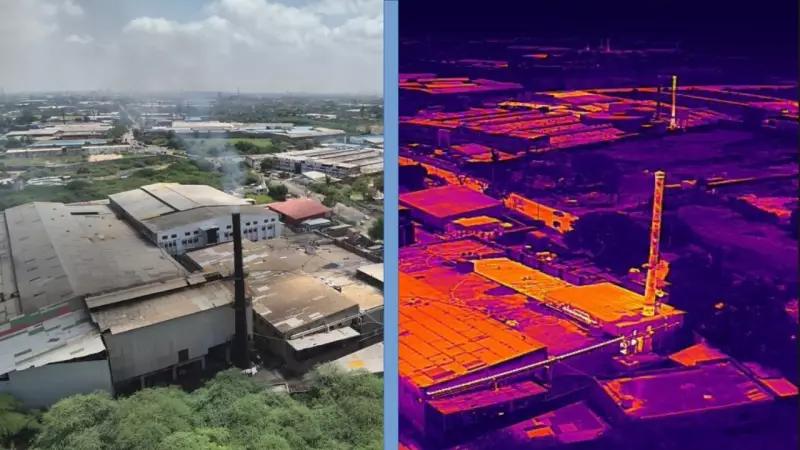
Real-World Testing in Tumakuru
The technology is already being put to the test in a practical setting. In Tumakuru, 76km from Bengaluru, a pilot project uses drone-mounted thermal sensors combined with satellite data layers. The focus is on a 40-acre solid-waste dump, where the system helps spot methane leaks and track heat build-up.
Ashwija BV, MD & CEO of Tumakuru Smart City Limited and commissioner of Tumakuru City Corporation, highlighted the project's benefits. "With new technologies like thermal intelligence via satellites and drones, we can now see and solve problems faster," she said. The pilot demonstrates two key applications. First, it pinpoints exact locations of methane release across vast landfills, allowing targeted action instead of searching tens of acres. Second, the thermal layers help the city plan plantations, shade structures, and water supply where they will most effectively combat urban heat.
Beyond City Planning: Protecting Outdoor Workers
SatLeo sees a significant market in managing the health and safety of India's vast outdoor workforce. Bhati points out that average city temperatures are meaningless for a gig worker on a specific street at noon. Detailed street-level thermal maps could enable a range of protections.
Insurers could verify heat-exposure claims, employers could reschedule or redirect tasks during heat spikes, and health departments could position cooling stations and medicines with precision. "If the temperature is going above 48°C and up, then the person is insured… but who will make sure where the people were working that the temperature of that location was 48°C?" Bhati asked, underlining the gap their data aims to fill.
One of their planned products, the "Thermal Comfort API," would allow municipalities or platforms to integrate heat stress measurements directly into their systems. Co-founder Urmil Bakhai noted the firm's grounded ambition, revealing they have letters of intent worth $25 million from public and private players. For city managers, the appeal is targeted, cost-effective action. For residents and workers, the benefit is simpler: cooler routes, better-placed trees, and faster detection of harmful emissions.