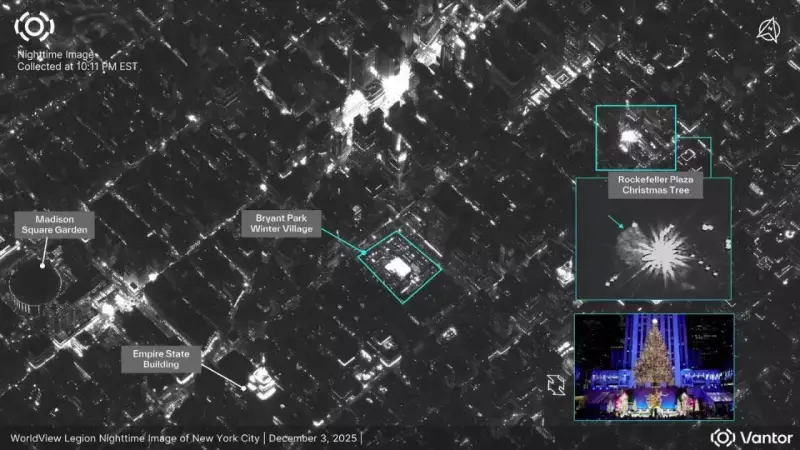
High-resolution satellite imagery is transforming modern observation, changing how experts and the public understand activities on Earth. A recent social media post by Vantor on X, formerly known as Twitter, perfectly highlighted this shift. The post shared remarkably clear nighttime images of the iconic Rockefeller Plaza Christmas Tree lighting ceremony in New York City. This demonstration captured public attention by showing how today's commercial satellites can observe detailed scenes after dark from orbit, remaining both distant and unobtrusive.
The Surprising Clarity of Nighttime Satellite Vision
The images highlighted by Vantor reveal a significant technological leap. Modern satellites can now record low-light conditions with a precision that was nearly impossible just a decade ago. This is made possible by major improvements in optical sensors, advanced noise reduction techniques, and sophisticated short-exposure tracking systems. These advancements allow satellites to detect subtle variations in light, track crowd movements, and map structural layouts during evening events with great accuracy.
Researchers who study nocturnal urban behaviour find these capabilities invaluable. The technology supports critical work on understanding population density shifts, analysing how public spaces are used after sunset, and monitoring energy distribution patterns. The Rockefeller Plaza ceremony, with its brilliant festive displays and steady stream of visitors, created a perfect natural laboratory. It allowed for the observation of how people navigate intensely crowded areas in a celebratory setting.

The resulting satellite images provided a unique overhead view of pedestrian flow patterns, queue formations, and vehicle clustering around the plaza. Such data is crucial for urban planners and mobility studies, contributing to datasets that help design smarter, safer cities.
Public Events as Perfect Testing Grounds for Orbital Tech
Why use a Christmas tree lighting for such a demonstration? Large seasonal celebrations like this offer ideal testing environments for satellite imaging teams. The Rockefeller Plaza event is particularly effective due to its combination of intense artificial illumination, reflective surfaces from ice rinks and buildings, and large crowds concentrated in a compact urban space. These conditions create a rich, visually diverse scene that challenges imaging systems.
Engineers can rigorously evaluate sensor stability, contrast handling, and imaging algorithm performance by analysing how satellites record the complex interplay of bright lights, deep shadows, and constant movement. Technology commentators note that annual events provide consistent reference points. This allows teams to measure year-on-year improvements in image clarity, exposure control, and overall system capability.
Sample images from major public gatherings frequently feature in data releases precisely because they present conditions that test a satellite's ability to interpret extreme brightness variations and maintain fine detail without distortion. In this sense, the festive ceremony serves a dual purpose: it is a beloved cultural marker and a valuable technical benchmark demonstrating the rapid progress of orbital imaging systems.
The Dual-Use Nature and Public Perception of Satellite Imaging
Vantor's reference to 'mission readiness' in the post underscores an important point: the dual-use nature of many satellite systems. Platforms designed for commercial sectors like construction monitoring or environmental assessment often possess capabilities that are equally valuable for emergency response teams or defence agencies. When a peaceful holiday ceremony becomes the subject of a public demonstration, it shows how readily these tools can adapt to complex real-world conditions—including dense crowds, variable lighting, and continuous motion.

Analysts point out that the same sensors capturing a festive gathering can, in a different context, be deployed to assess storm damage, verify terrain changes after natural disasters, or support humanitarian logistics in crisis zones. The Rockefeller Plaza example serves as a subtle reminder that observational technology must function reliably across a wide spectrum of circumstances. Its use in a civilian, public setting also helps demystify the technology, illustrating that high-resolution imaging can be both operationally powerful and non-intrusive in everyday life.
Public reactions to such shared images often include curiosity about how often satellites observe populated areas and what they can truly see. Privacy researchers clarify that while modern systems excel at detecting broad patterns and spatial relationships, they are typically unable to identify individuals due to operational altitude, resolution limits, and motion blur. The primary value lies in understanding how public spaces are utilized at a macro level.
The discussion sparked by the Rockefeller Plaza post highlights the growing need for clear communication when powerful imaging tools are showcased. Transparency about sensor performance, image processing methods, and intended applications is becoming essential to build public trust. As orbital imagery becomes more visible in everyday contexts, public familiarity with these 'satellite perspectives' is gradually shaping expectations about responsible data collection and handling.