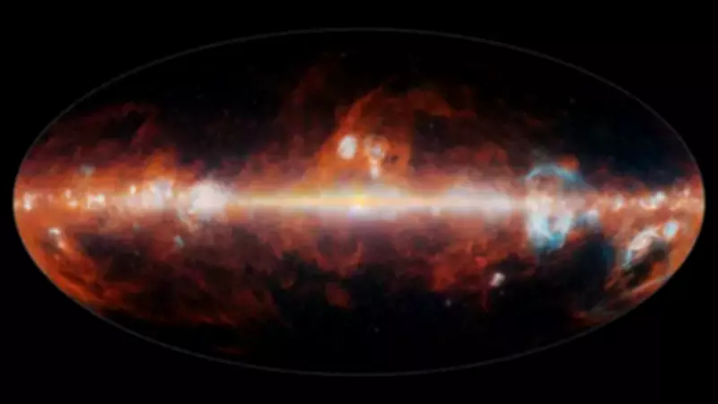
NASA's SPHEREx Telescope Creates Historic 102-Color Infrared Sky Map
Space observatories typically operate in quiet solitude, gathering vast amounts of data long before any images or findings reach public awareness. In a landmark achievement, NASA's SPHEREx space telescope has shattered expectations by producing the most detailed infrared map of the entire sky ever created.
Unprecedented Infrared Mapping Mission
Launched in March 2025, the SPHEREx telescope was specifically designed with a singular, ambitious objective: to conduct a comprehensive scan of the entire celestial sphere using infrared light. By December of that same year, the mission had already accomplished its first complete sky map, capturing observations across an astonishing 102 separate infrared wavelengths.
These colors exist beyond human visual perception, yet they carry immensely detailed information about galaxies, stars, and interstellar materials. This dataset represents the first time in astronomical history that the entire sky has been mapped with such spectral richness in the infrared spectrum.

Technical Marvel of Spectral Imaging
The SPHEREx telescope orbits Earth approximately fourteen and a half times daily, traversing over the poles as our planet rotates beneath it. Each day, it captures about 3,600 images along a circular strip of sky. Over a six-month period, these shifting perspectives gradually assemble into a complete 360-degree celestial map.
Each of the 102 colors corresponds to a specific infrared wavelength, effectively creating 102 overlapping maps of the same cosmic vista. The telescope employs spectroscopy—a technique that separates light into its component wavelengths—to achieve this remarkable feat. Different wavelengths reveal distinct physical processes: dust clouds glow brightly at certain infrared bands while disappearing at others, and distant galaxies exhibit subtle color shifts that indicate their vast distances from Earth.
Strategic Positioning Among Space Observatories
Previous missions like the Wide-field Infrared Survey Explorer have mapped the entire sky, but with significantly fewer infrared bands. At the opposite extreme, the James Webb Space Telescope conducts exquisitely detailed spectroscopy but over a much narrower field of view.
SPHEREx occupies a crucial middle ground between these approaches. Rather than focusing narrowly on individual targets, it conducts comprehensive surveys of everything in its path, repeatedly scanning the cosmos. The telescope utilizes six detectors, each equipped with a filter containing a gradient of 17 colors. Consequently, every single image simultaneously records data across all 102 wavelengths, enabling the steady construction of an unprecedented cosmic census.
Revolutionary Three-Dimensional Galaxy Mapping
One of the mission's primary scientific objectives involves measuring distances to hundreds of millions of galaxies. While many of these galaxies have already been mapped in two dimensions by other observatories, SPHEREx adds the crucial third dimension by estimating distances through infrared color signatures.
This three-dimensional map will empower scientists to study how galaxies cluster across vast cosmic scales. These patterns may contain vital clues about cosmic inflation—the rapid expansion believed to have occurred in the first fraction of a second following the Big Bang. This primordial expansion fundamentally shaped the large-scale structure of our universe, and subtle variations in galaxy distribution could provide indirect evidence of how this extraordinary process unfolded.
Searching for Life's Building Blocks
Beyond cosmological investigations, the SPHEREx mission will meticulously examine the Milky Way for water ice and organic molecules. Infrared wavelengths prove particularly well-suited for detecting these compounds within cold molecular clouds where stars and planetary systems form.
The complete dataset has been made publicly available to the global scientific community. During its primary two-year mission, the telescope is scheduled to complete three additional all-sky scans. Sensitivity will improve progressively as these multiple maps are combined and analyzed.

For now, the first mosaic stands as an extraordinarily detailed infrared portrait of our sky. While visually it may appear as layered maps of faint color shifts and numerical data rather than dramatic imagery, the scientific implications promise to reshape our understanding of the cosmos for years to come.