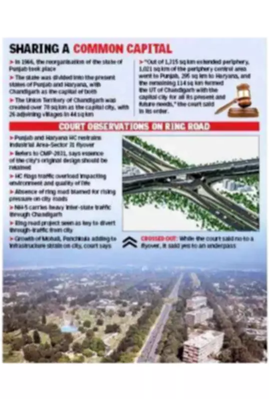
The Punjab and Haryana high court on Friday strongly recommended that Chandigarh remain an administrative city, as originally planned, and restrained the construction of the Industrial Area–Sector 31 flyover. The court stated that the Chandigarh Master Plan (CMP) 2031 emphasizes efforts to retain the essence of the city's original plan.
Ring Road Necessity Highlighted
In its detailed order, the court referred to the planned ring road on the periphery of Chandigarh, noting that its absence has immensely increased pressure on city roads. The court observed, "Ring road in the periphery of Chandigarh town was prescribed, and it was stipulated in CMP-2031 that in the absence of ring roads, the city roads, which provide the shortest travel distance between towns, are likely to be put under extreme pressure to the detriment of the city's environment and quality of life."
Current Traffic Situation
Currently, Chandigarh experiences heavy traffic from commuters traveling to neighboring states of Punjab, Haryana, and Himachal Pradesh, among other areas. Much of this traffic passes through National Highway 5, where the flyover at the Industrial Area–Sector 31 rotary was planned. The high court restrained this project on Friday. Sources indicate that if the ring road is constructed, a significant portion of this traffic would not enter the city.

The Ministry of Road Transport and Highways has already initiated the process for the ring road project. The proposed road will provide direct, high-speed access to Zirakpur and Panchkula for traffic coming from Chandigarh, Ambala, and Delhi, and will also enable faster movement towards Himachal Pradesh.
Adherence to Master Plan
Underlining the need to adhere to the master plan, the court noted that the first phase of the city (Sectors 1 to 30) occupies about 33.37% of the grid area. The court stated, "CMP-2031 also stipulates that efforts should be made to retain the essence of the original plan of the city." The first phase was designed to be low-rise and green, and the court observed that extensive growth of Mohali and Panchkula is putting immense pressure on Chandigarh.
Regional Development Context
The court order elaborated: "In 2008, the GMADA Regional Plan 2056 was notified, which, inter alia, declared the area north of Chandigarh, abutting the Capitol Complex created by Le Corbusier and consisting of village settlements Nayagaon and Kansal, as a nagar panchayat. In a similar manner, the Haryana government planned five settlements. Of these, Panchkula and Panchkula Extension-1 across the Ghaggar river stand fully developed. Panchkula Extension, Panchkula Extension-2, Shree Mata Mansa Devi Complex (MMDC), comprising 1,550 acres close to Sukhna Lake, and the Kalka-Pinjore Urban Complex were developed."
Historical Background
In 1966, the reorganisation of the state of Punjab took place, dividing it into the present states of Punjab and Haryana, with Chandigarh as the capital of both. The Union Territory of Chandigarh was created over 70 sq km as the capital city, with 26 adjoining villages in 44 sq km. The court stated, "Out of 1,315 sq km extended periphery, 1,021 sq km of the periphery control area went to Punjab, 295 sq km to Haryana, and the remaining 114 sq km formed the UT of Chandigarh with the capital city for all its present and future needs."