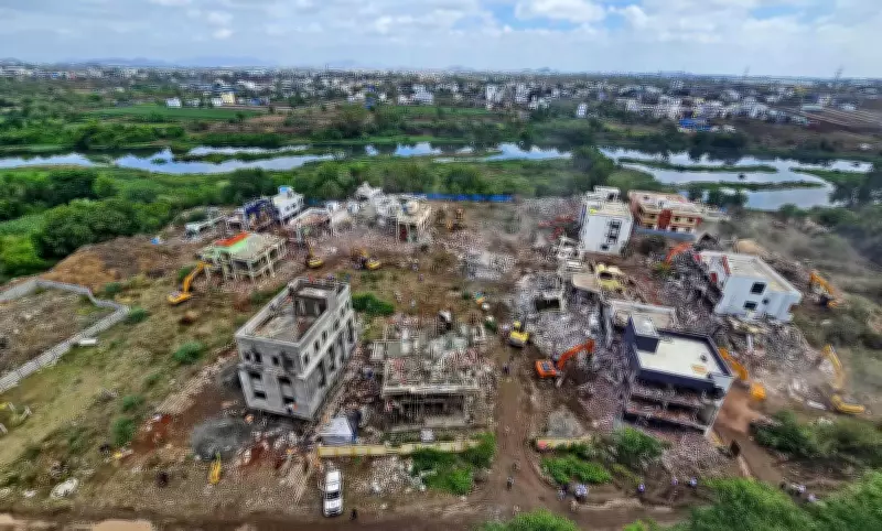
Nearly a year after the Pimpri Chinchwad Municipal Corporation demolished 36 illegal bungalows in Chikhali over flood-line violations, another 20 residential structures in the Moi Phata area have come under scrutiny for being located within the blue flood line of the Indrayani river.
NGT Committee Findings
A joint committee appointed by the National Green Tribunal (NGT), in a report submitted in a petition filed by activist Gopal Kachave in 2023, found that all 20 structures are along the Ram Zara nullah, a tributary that joins the Indrayani. The report noted that the nullah itself falls within both blue and red flood lines, raising concerns that the constructions could obstruct natural water flow and pose long-term risks.
Upcoming Hearing and Possible Demolition
The tribunal is scheduled to hear the matter on July 24, and the findings have raised the possibility of a demolition drive similar to last year's action in Chikhali following directions from the NGT and the Supreme Court.

Civic Officials' Response
Civic officials claimed that the structures were built between January and November 2022 without PCMC permissions. Notices were issued, and four under-construction structures spread over 441 square metres were demolished in October 2023. However, the constructions were rebuilt despite the action.
“We have served notices to all occupants and identified the structures for demolition. However, since the matter is sub judice before the NGT, we are awaiting final orders,” said Ajinkya Yele, assistant municipal commissioner and ‘K’ ward officer, adding that the houses are along the nullah bank.
Property Owners' Concerns
Property owners claimed they were unaware of the flood-line restrictions while purchasing the plots. “If we knew that the houses could be demolished, we would not have invested our savings in building them,” a property owner said.
Activists' Criticism
Activists accused civic authorities of failing to act in time. “It is the local ward office and municipal officials’ responsibility to monitor illegal constructions, especially those coming up in the flood-line areas,” activist Sarang Yadwadkar said. He added that a state government resolution mandates local bodies to periodically monitor their jurisdictions using satellite and Google imagery to identify illegal constructions and unauthorised tree felling at least once every six months.
Background of the Case
The issue first surfaced in November 2023 when Kachave approached the NGT seeking action against the constructions. During the proceedings, the tribunal made all 20 property owners and officials of the irrigation department parties to the case. In September 2025, the NGT directed formation of a joint committee following a request by the owners’ lawyer, with the district collector’s office acting as the nodal agency, to inspect the site and submit a detailed report.
Flood Lines at a Glance
Blue Flood Line
The line marked at the water level of the highest discharge of:
- Flood discharge at the average frequency of 25 years
- One-and-a-half times the discharge of the established riverbed
Red Flood Line
The line marked at the level of water discharge as under:

- Where there is no dam, flood discharge at the average frequency of 100 years
- Where there is a dam, maximum flood discharge over the spillway added with flood discharge from the free catchment area at the average frequency of 100 years