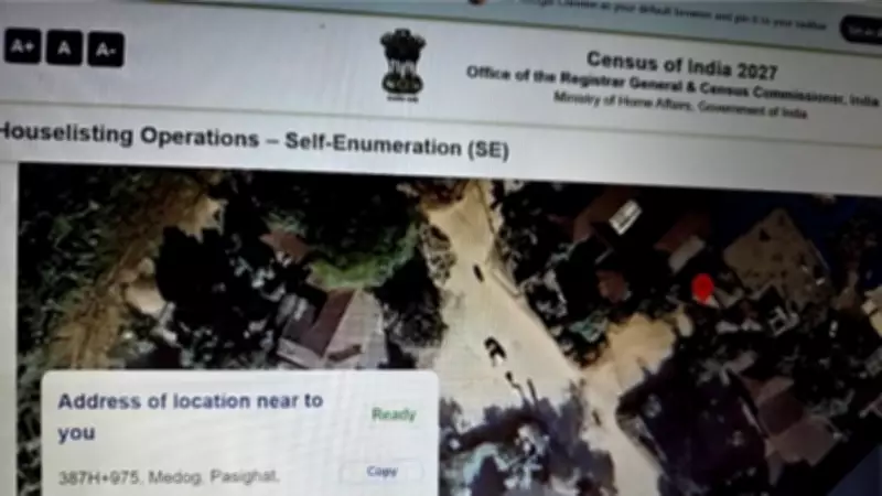
Government Acts Swiftly to Rectify Census Portal Mapping Error
In a significant development, the Indian government has promptly addressed and resolved a critical mapping discrepancy on the official census portal. The issue came to light during self-enumeration activities when users discovered that the online maps incorrectly depicted the town of Pasighat, located in the East Siang District of Arunachal Pradesh, as being part of Medog county in China.
Immediate Response and Resolution
The error was reported through the official Census India 2027 Twitter account on April 18, 2026. According to the post, the matter was immediately escalated to the map services provider responsible for the portal's geographic data. Government authorities confirmed that the technical glitch was fixed without delay, ensuring the accurate representation of India's territorial integrity on the digital platform.
This incident underscores the importance of precise cartographic data in official government portals, especially in regions with sensitive geopolitical implications. The swift correction demonstrates the government's commitment to maintaining accurate national boundaries in all digital interfaces.

Broader Implications and Context
Arunachal Pradesh has long been a point of contention between India and China, with Beijing repeatedly making unfounded territorial claims over the state. This mapping error, though technical in nature, could have been misinterpreted without prompt action. The government's rapid response helps prevent any potential diplomatic misunderstandings or misinformation.
The census portal, accessible at se.census.gov.in, is a crucial tool for the ongoing 2027 national census, allowing citizens to participate in self-enumeration. Ensuring its accuracy is paramount for both statistical integrity and national sovereignty.
Key aspects of this development include:
- The error was identified during routine self-enumeration activities by users
- Official channels were used to report and address the issue promptly
- The map services provider was directly engaged to implement the correction
- This incident highlights the ongoing need for vigilance in digital mapping technologies
While the technical issue has been resolved, this event serves as a reminder of the complexities involved in maintaining accurate digital representations of politically sensitive regions. The government's proactive approach in this matter reinforces India's firm stance on its territorial sovereignty.