Gujarat's NH-48 Stretch Identified as High-Risk Zone After 281 Fatalities in Two Years
The Gujarat Road Safety Authority (GRSA) has officially designated a critical 64.7-kilometer segment of National Highway 48, spanning from Vemali in Vadodara district to Varedia in Bharuch, as one of the state's most vulnerable stretches for road accidents. This alarming classification follows a detailed analysis of accident data, which reveals a persistent pattern of dangerous driving behaviors leading to tragic outcomes.
Shocking Statistics Highlight Wrong-Way Driving Crisis
According to the GRSA annual report for 2024-25, presented during the recent Gujarat assembly budget session, this highway section witnessed a staggering 253 fatal accidents between 2022 and 2024. These incidents resulted in 281 fatalities, with head-on collisions accounting for 53 of those deaths. The report explicitly points to wrong-way driving as a primary culprit, noting that despite the road being a four-lane divided highway, such collisions are disturbingly common.
Breakdown of Accident Types and Fatalities:

- Head-on collisions: 47 incidents leading to 53 deaths.
- Rear-end collisions: 62 incidents resulting in 66 fatalities.
- Side collisions: 30 occurrences causing 31 deaths.
- Pedestrian fatalities: 78 pedestrians lost their lives on this stretch during the same period.
Proactive Measures and Database Utilization
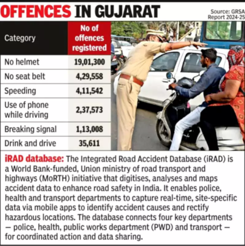
In response to these grim figures, GRSA has leveraged the Integrated Road Accident Database (iRAD) to identify 20 high-risk stretches across Gujarat, including the Vemali-Varedia corridor. This data has been forwarded to relevant District Road Safety Committees (DRSC) and City Road Safety Committees (CRSC) for immediate investigation and implementation of corrective actions. The iRAD system, a World Bank-funded initiative by the Union Ministry of Road Transport and Highways, digitizes and analyzes accident data to enhance road safety through coordinated efforts among police, health, transport, and public works departments.
During the 2024-25 period, GRSA conducted extensive site visits to 32 identified blind spots in districts such as Navsari, Narmada, Surat, and Mahisagar, along with 12 additional inspections of particularly vulnerable road segments. Based on these assessments, the authority has proposed targeted safety interventions tailored to address specific challenges at each location, aiming to mitigate risks and prevent future tragedies.
Understanding the iRAD Database
The Integrated Road Accident Database (iRAD) represents a significant advancement in India's road safety infrastructure. Funded by the World Bank and overseen by MoRTH, this initiative focuses on digitizing, analyzing, and mapping accident data to identify hazardous locations and their underlying causes. By enabling real-time, site-specific data capture via mobile apps, iRAD facilitates coordinated action among key departments, fostering a more proactive approach to road safety management and accident prevention.