Maharashtra Government Revises Nagpur-Goa Expressway Alignment Following Local Opposition
The Maharashtra government has announced a significant revision to the proposed alignment of the Nagpur-Goa Maharashtra Shaktipeeth Expressway. This decision comes in response to strong opposition from farmers and local political leaders in the south-western regions of the state. The state cabinet recently approved a government resolution to formalize these changes, marking a pivotal moment for this ambitious infrastructure project.
Increased Length and Route Modifications
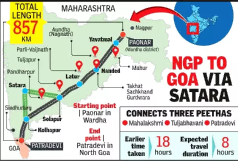
The total length of the expressway has been increased from the originally planned 802.592 kilometers to 856.765 kilometers. This extension incorporates substantial route changes across multiple districts. A key development is the inclusion of Satara district into the project's scope, expanding the number of districts connected from 12 to 13.
The project is being implemented by the Maharashtra State Road Development Corporation (MSRDC). According to MSRDC sources, the realignment was necessary to address conflicting local demands. "While one group opposed the expressway passing through their land, the other wanted it to pass through it. The realignment was done to accommodate concerns of both groups," the sources explained.

Background and Review Process
The corridor initially received administrative approval in February 2024 for a stretch from Pavnar in Wardha district to Patradevi in Sindhudurg before reaching Goa. However, resistance to land acquisition, particularly in Kolhapur and adjoining areas, led to the cancellation of earlier notifications and prompted a comprehensive review of the entire alignment.
Following directions issued in August 2025, MSRDC undertook a detailed evaluation process:
- Assessment of multiple alternative routes, with the Pavnar-Sangli stretch retained as originally planned.
- Consultations with ministers and people's representatives to gather stakeholder input.
- Field inspections and comparative assessments based on Indian Roads Congress guidelines.
Detailed Alignment Changes
The revised alignment maintains the existing route through Wardha, Yavatmal, Beed, and Latur districts. However, substantial modifications have been implemented in several other regions:
- Nanded District
- Hingoli District
- Parbhani District
- Dharashiv District
- Solapur District
- Sangli District
- Kolhapur District
- Sindhudurg District
The expressway will now run from Pavnar (Digraj) in Wardha district to Banda in Sawantwadi taluka of Sindhudurg, covering the increased length of 856.765 kilometers.
Project Scope and Expected Benefits
Spanning 13 districts and 40 talukas, the Nagpur-Goa Maharashtra Shaktipeeth Expressway represents a major infrastructure initiative with multiple objectives:
- Enhanced Connectivity: Improving transportation links across Maharashtra's diverse regions.
- Religious Tourism: Connecting 21 important religious destinations, including major Shaktipeeths such as Mahur, Tuljapur, and Kolhapur.
- Regional Development: Stimulating economic growth and development in areas along the route.
- Tourism Boost: Facilitating easier access to tourist destinations across the state.
Once completed, this high-speed corridor is projected to dramatically reduce travel time between Nagpur and Goa from the current 18 hours to approximately 8 hours. This represents a significant advancement for Maharashtra's transport network and underscores the state's commitment to infrastructure development that balances progress with local concerns.