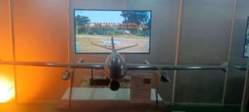
Southern Command Unveils Indigenous SOM Surveillance Drone, Boosting Army's ISR Capabilities
The Indian Army's Southern Command has achieved a significant milestone in defense technology with the development of an indigenously designed long-range fixed-wing surveillance drone. Named SOM, this advanced unmanned aerial system represents a strategic enhancement to real-time intelligence, surveillance, and reconnaissance (ISR) capabilities across operational zones, drawing directly from recent battlefield experiences including Operation Sindoor.
Development and Strategic Context
Engineered by the 21 Corps Zonal Workshop in Bhopal under Southern Command's supervision, the SOM drone embodies the Army's evolving operational doctrine where unmanned systems are increasingly recognized as critical force multipliers. Senior military officials emphasize that modern warfare demands persistent aerial surveillance, rapid target acquisition, and real-time situational awareness—capabilities that proved decisive during Operation Sindoor and other recent engagements.
The drone was prominently showcased during the Jointness Atmanirbharta and Innovation (JAI) seminar organized by Southern Command last week, highlighting the Army's commitment to self-reliance in defense technology.

Technical Specifications and Performance
Designed with emphasis on endurance, range, and operational flexibility, the SOM drone boasts impressive technical parameters:
- Operational Range: 30 kilometers in one-way mission profile
- Altitude Capability: Up to 2,000 meters above ground level
- Endurance: 120 minutes of continuous flight
- Speed: Up to 90 meters per second
- Wind Resistance: Stable operation in wind speeds up to 10 m/s
- Temperature Range: Operational from –10°C to +50°C
The platform features a fully indigenous carbon-fibre airframe and supports multiple operational modes including autonomous, tele-operated, and manual controls, allowing commanders to adapt deployment based on mission complexity.
Advanced Imaging and Navigation Systems
The SOM drone's imaging system provides a substantial operational advantage with its daylight camera capable of recording 4K video at 30 frames per second and offering combined zoom capability up to 180x. This enables detailed stand-off observation of targets from significant distances.
Real-time video telemetry up to 30 kilometers without latency allows commanders to make time-sensitive decisions—a capability increasingly viewed as indispensable after Operation Sindoor highlighted the operational costs of delayed or fragmented intelligence.
Navigation is supported by a sophisticated multi-constellation system incorporating IRNSS, GPS, Galileo, GLONASS, and BeiDou, with Real-Time Kinematic (RTK) capability ensuring high positional accuracy even in complex electromagnetic environments.
Operational Features and Future Applications
The drone incorporates several features directly addressing operational requirements identified by field commanders during exercises and actual operations. These include automatic take-off, position hold, and area survey functions that enhance rapid deployment while minimizing human exposure in technology-driven battlefields.
Operational planners envision the system expanding beyond surveillance to include precision payload delivery and future integration with loitering munitions and electronic warfare suites. This adaptability mirrors the Army's post-Sindoor emphasis on layered ISR, precision engagement, and unmanned dominance in tactical battlespace.
Testing and Cost-Effectiveness
Trial runs successfully validated the drone's 30-kilometer range at the Babina Field Firing Range in August last year. At an estimated cost of Rs 15.75 lakh per unit, this in-house development underscores the Army's push for cost-effective indigenous solutions under the Atmanirbhar Bharat initiative.

Strategic Implications
As Operation Sindoor demonstrated, future conflicts will be decided as much by sensors and data dominance as by traditional firepower. Systems like SOM signal the Army's intent to internalize operational lessons and institutionalize unmanned surveillance as a core operational capability. The development represents a significant step toward achieving unmanned aerial superiority in India's diverse operational theaters.
Senior officers noted that the drone's ability to operate across multiple frequency bands and withstand extreme temperature variations makes it particularly suited for India's varied geographical conditions, from high-altitude regions to desert environments.