Global Study Reveals How Map Distortions and Cognitive Bias Shape Our Worldview
Maps are ubiquitous fixtures in classrooms, on news websites, and within our phone screens. They present an image of settled precision, yet the world they depict is invariably distorted. This distortion arises from a fundamental geometric challenge: representing our round Earth on a flat surface inevitably requires stretching or compressing certain areas. Over centuries, specific map projections have become ingrained in public consciousness, with the Mercator projection being particularly prominent. Critics have long contended that repeated exposure to such maps may subtly alter how individuals perceive the relative sizes of continents and nations.
Examining the Mercator Effect on Perception
A comprehensive international study titled "The Influence of Map Projections on People’s Global-Scale Cognitive Map: A Worldwide Study", published on MDPI, sought to quantify this concern. Researchers gathered responses from more than 130,000 participants globally, comparing their estimations of country sizes against various map projections and the true proportions of a globe. The findings provide substantial empirical support to ongoing debates within cartography and cognitive science.
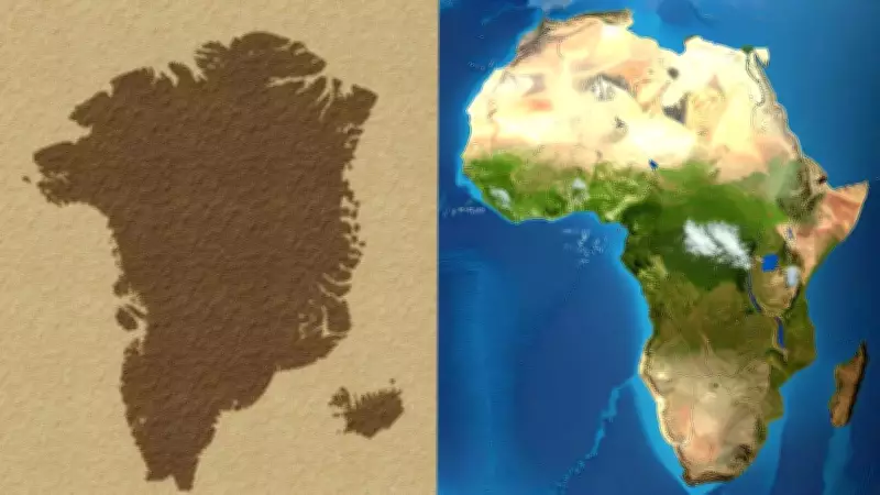
On a globe, the vast difference between Africa and Greenland is unmistakable. Africa's immense landmass spans the equator, extending into both hemispheres, while Greenland is situated far to the north, occupying a significantly smaller area. In reality, Africa is approximately fourteen times larger than Greenland—a substantial geographic fact, not a minor discrepancy. However, when the curved surface of Earth is flattened for display, this clarity is lost. The Mercator projection, developed in the sixteenth century for nautical navigation, preserves angles to aid sailors in plotting straight courses but critically fails to preserve area accuracy.

As latitude increases, landmasses on the Mercator projection are stretched both vertically and horizontally. Greenland, located near the Arctic Circle, undergoes dramatic expansion, while Africa, largely positioned near the equator, remains closer to its true scale. This systematic distortion affects all high-latitude regions, making the map persuasive yet misleading in terms of area representation.
The Inherent Limitations of Flat Maps
It is a cartographic truth that any flat world map must compromise. Some projections, known as equal-area maps, prioritize preserving area at the expense of shape or direction, thereby reducing the Greenland effect but introducing other distortions. While globe-based digital maps have gained popularity, the familiar flat world map continues to dominate media and educational materials. The issue is not one of intentional deception but rather an unavoidable consequence of geometry.
Cognitive Bias: A Stronger Influence Than Map Exposure
Interestingly, the study uncovered a consistent psychological pattern that overshadowed the impact of specific map projections. Participants frequently overestimated the sizes of smaller countries and underestimated larger ones. This bias was robust across various reference cases, including Japan, South Africa, and the United States.
Researchers noted that this tendency aligns with established psychophysical principles, where human judgment does not scale linearly with physical dimensions. This cognitive bias appears to exert a more powerful influence on size perception than repeated exposure to any particular map style.
Limited Impact of Projection Familiarity
The study also assessed participants' familiarity with different map projections, such as the Robinson and Gall–Peters projections. Surprisingly, this familiarity did not correlate with more accurate or distorted size estimates. The broader implication is that our global cognitive maps are shaped by a mosaic of experiences—media, travel, education—rather than being dominated by a single cartographic image. While distortions remain stark on paper, they tend to soften within the human mind.